Every year various government exams are conducted and neighbouring countries of India is one of the most important topic for general awareness section.
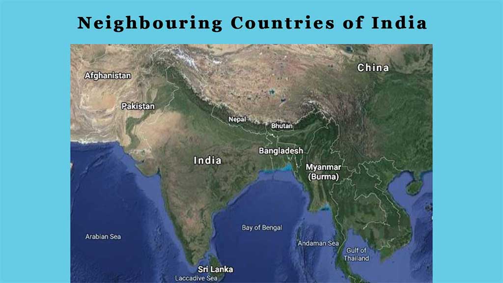
We will discuss the neighbouring countries of India to which it is attached through land or sea. India share boundary with 9 countries, out of which two are of sea border and rest 7 is land borders.
Geographical Features of India
Indian subcontinent is located in the northern and eastern hemisphere, and southern part of Asia. Length of the frontier is 15106.7 km and the length of the coastline of Lakshadweep islands, Andaman and Nicobar Islands and mainland is 7516.6 km having third largest international border after China and Russia.
India is the seventh largest country in the world in terms of area and second largest in terms of population. Brief description about India is given below:
- Country Name: India
- Capital: New Delhi
- Land Frontier: 15106.7 km
- Total Coastline: 7516.6 km
List of Neighbouring Countries of India
Below we shall discuss about the neighbouring countries of India in detail. The neighbouring countries of India are:
Also Read: Components and Functions of Indian Financial System
1. Afghanistan
- Capital: Kabul
- Attached Indian States: Ladakh (PoK)
- Border Length: 106 km
- Area: 6,52,230 square km, world’s 41st
- Currency: Afghan Afghani
- Official Language: Dari, Pashto
- State /Provinces: 34 Provinces
- Highest Peak: Noshaq (7492 km)
- Main River: Amu River
Afghanistan is located in the central Asia having an area of 6,52,230 square km which is surrounded by lands only.
In the past, it was famous as Ariana or Bactria. Islam is the most prevalent religion in Afghanistan. Manufacture of cotton, textiles, woven carpets, handcrafts and woolens are major industrial activities.
Agriculture is the main source of income. Border line between India and Afghanistan is termed as Duran Line.
2. Bangladesh
- Capital: Dhaka
- Attached Indian States: West Bengal, Meghalaya, Mizoram, Tripura and Assam.
- Border Length: 4096.7 km
- Area: 1,48,393 square km, 92nd in the world
- Currency: Bangladeshi Taka
- Official Language: Bengali
- Highest Peak: Keokradong (2,223 m)
- Main River: Padma
India and Bangladesh border is one of the longest border in the world.
3. Bhutan
- Capital: Thimphu
- Attached Indian States: West Bengal, Sikkim, Arunachal Pradesh & Assam
- Border Length: 699 km
- Area: 46,500 square km, 133rd in the world
- Currency: Ngultrum
- Official Language: Dzongkha
- State /Provinces: 20 states
- Highest Peak: Gangkhar puensum (7570m)
- Main River: Manas
Bhutan has an area of about 46,500 square km and 699 km is the length of border between India and Bhutan with India’s 4 States. Most of the population of Bhutan follow Buddhism. Parliamentarian form of government is observed.
Bhutan is a hilly area and has an optimum condition to install Hydroelectric Power Project which is the major source of income and other than this agriculture, forestry, and tourism is also the source of income.
4. China
- Capital: Beijing
- Attached Indian States: Ladakh, Himachal Pradesh, Uttarakhand, Sikkim and Arunachal Pradesh
- Border Length: 3488 km
- Area: 95,96,961 square km (3rd /4th in the world)
- Currency: Chinese Yuan
- Official Language: Mandarin
- State /Provinces: 26 Provinces
- Main River: Yangtze
In terms of population China is the most populated country in the world having an area of about 95,96,961 square km. China is considered as one of the fastest growing economy in the world.
There are two heads in China one is president of China who is head of the state while other is Prime Minister of China who is head of the government. The silk road was originated from China. Border between India and China is known as McMahon Line.
5. Myanmar
- Capital: Naypyidaw
- Attached Indian States: Arunachal Pradesh, Nagaland, Mizoram and Manipur
- Border Length: 1643 km
- Area: 6,76,578 square km, 39th in the world
- Currency: Burmese Kyat
- Official Language: Burmese
- Highest Peak: Hkakabo Razi (5881m)
- Main River: Irrawaddy River (2170km)
It is located in the eastern side of India having an area of about 6,76,578 square km. In Myanmar, a bicameral legislature governs Presidential republic. Former capital of Myanmar was Yangon. Formerly, Myanmar was known as Burma.
6. Nepal
- Capital: Kathmandu
- Attached Indian States: Bihar, Uttarakhand, UP, Sikkim and West Bengal
- Border Length: 1751 km
- Area: 1,47,181 square km, 93rd in the world.
- Currency: Nepalese Rupee
- Official Language: Nepali
- State /Provinces: 7 Provinces
- Highest Peak: Mount Everest (8,848m)
- Main River: Karnali (1080km)
Mount Everest, the tallest peak of the world is situated in Nepal. Nepal is in the North-East of India having an area of about 1,47,181 square km. Major source of income comes from tourism. The government is a federal parliamentary republic. Eight out of ten worlds’ tallest peak is located here.
7. Pakistan
- Capital: Islamabad
- Attached Indian States: Jammu and Kashmir, Ladakh, Punjab, Rajasthan
- Border Length: 3323 km
- Area: 7,96,095 square km, 33rd in the world
- Currency: Pakistani Rupee
- Official Language: Urdu
- State /Provinces: 4 Provinces
- Highest Peak: K2 (8611m)
- Main River: Indus River
Once Pakistan was a part of India but it was separated from India and formed Pakistan. Head of the country is Prime Minister and all other decisions are taken under his supervision. Location of Pakistan is to the west of India.
Initially Bangladesh was a part of Pakistan and was known as East Pakistan. Border between India and Pakistan is known as Radcliffe Line.
8. Sri Lanka
- Capital: Sri Jayawardenepura Kotte (Legislative Capital) and Colombo (Executive Capital)
- Attached Indian States: It is separated to India by Gulf of Mannar
- Border Line: Sea Border
- Area: 65,610 square km, 120th in the world
- Currency: Sri Lankan Rupee
- Official Language: Sinhala, Tamil
- State /Provinces: 9 States
- Highest Peak: Pidurutalagala (2524 m)
- Main River: Mahawali Ganga (335 km)
Officially Sri Lanka is known as the Democratic Socialist Republic of Sri Lanka. It is separated from India by Palk Strait in the southern side of India. It has two capitals, one is Sri Jayawardenepura Kotte which is legislative capital of Sri Lanka and the other is Colombo which is the executive capital of Sri Lanka.
Here, Chief of the state and head of the government is president of Sri Lanka. Sri Lanka is famous for tourism.
9. Maldives
- Capital: Male
- Attached Indian States: It lies in the south-west part of India Ocean below the Lakshadweep Island
- Border Line: Sea Border
- Area: 298 square km, 187th in the world
- Currency: Maldivian Rufiyaa
- Official Language: Dhivehi
- State /Provinces: 1
Maldives is situated in the south-west of India which is an island country. The area of Maldives is very less and is considered as one of the smallest country in the world. Thousands of Coral islands formed the Maldives country. Being a presidential republic, head of the state is president. Major follower of this country is Islam.
Related Article:
We hope this post will help you to know the Neighbouring Countries of India. You can follow us on Facebook and Twitter for latest post notifications.
Frequently Asked Questions
Q1. How many countries are there which surrounded India?
Ans: There are 9 countries which surrounded India.
Q2. To which country India share longest boundary?
Ans: To the east of India, Bangladesh shares the longest boundaries with India which is 4096.7 km long.
Q3. To which country India shares shortest boundary?
Ans: To the north of India, Afghanistan shares the shortest boundary with India which is 106 km long.
Q4. How many states share boundary with Pakistan?
Ans: Pakistan share boundary with 5 States of India viz. Jammu and Kashmir, Ladakh, Punjab, Rajasthan and Gujarat.
Q5. How many Indian states share boundary with Nepal?
Ans: Nepal shares boundary with 5 Indian states viz. Bihar, Uttarakhand, UP, Sikkim and West Bengal.
Q6. Name the highest peak of Bhutan?
Ans: Gangkhar Puensum (7570m) is the highest peak of Bhutan.
Q7. Name the main river of China?
Ans: Yangtze is the main river of China.
Q8. Name the currency of Afghanistan?
Ans: Afghan Afghani is the currency of Afghanistan.
Q9. Name the official language of Maldives?
Ans: Dhivehi is the official language of Maldives.
Q10. Name the highest peak of Myanmar?
Ans: Hkakabo Razi (5881m) is the highest peak of Myanmar.